The benefits of Remote Sensing for Cultural Heritage monitoring, protection and management
Climate-driven storms cause catastrophic flooding around the world
Cultural Heritage sites are facing a serious threat from Climate Change
Extreme rainfall from Storm Daniel has hit parts of the central and eastern Mediterranean, leading to devastating flooding and loss of life in Greece, Turkey, Bulgaria and Libya, the worst affected country. Up to 10,000 people were reported missing by the Libyan Red Crescent Society, according to the International Federation of Red Cross and Red Crescent Societies. The number of casualties was not immediately confirmed, but hundreds were feared dead [1].
Libya’s National Meteorological Centre said that the storm reached a peak in northeastern Libya on 10 September, with strong winds of 70 – 80 km/h. This caused communications interruption and the fall of electricity towers and trees. Torrential rains of between 150 – 240 mm caused flash floods in several cities, including Al-Bayda, which recorded the highest daily rainfall rate of 414.1 mm (from 10 Sep 8 am to 11 Sep 8 am). The National Meteorological Centre said this was a new rainfall record. The flash floods also led to the death of many residents and great losses of property. Entire neighbourhoods in Derna disappeared, along with their residents swept away by water after two ageing dams collapsed making the situation catastrophic and out of control, said the Libyan meteorological service [1].
“While no formal attribution of the role of Climate Change in making Storm Daniel more intense has been conducted yet, it is safe to say that the Mediterranean Sea surface temperatures have been considerably above average throughout summer,” Dr Karsten Haustein, a climate scientist at Leipzig University told UK newspaper the Guardian. Storms draw more energy from warmer seas, while a hotter atmosphere holds more water vapour that can fall as rain, leading to more extreme deluges. From Brazil to China, countries around the world have been battling ferocious, climate-fuelled floods since the start of September [2].
In Greece, days of cataclysmic rainfall that began on 4 September burst dams, washed away roads and hurled cars into the sea. Some central regions received twice the average annual rainfall for Athens in the space of just 12 hours. The Thessalian plain, which is home to a quarter of the country’s agricultural production, had turned into a giant lake by 8 September. Turkey and Bulgaria were also battered by rains from Storm Daniel. At least five people were killed after a flash flood swept through their campsite in Turkey’s Kirklareli province. Another two people died in Istanbul where the storms on 5 September inundated hundreds of homes and workplaces. Nightmarish scenes emerged of crowds trapped inside Başakşehir National Library [2].
After passing through the Mediterranean Basin, Storm Daniel slammed into the northern coast of Libya on 9 September. It caused unprecedented flooding, bursting the dams that protected the port city of Derna. This unleashed raging waters that swept away residential neighbourhoods on both banks of the Wadi Derna river. Benghazi city was also hit by catastrophic flooding [2]. Storm Daniel hit also the region of Cyrenaica in north-eastern Libya, so called by the Romans but occupied since 631 BC by colonists from the island of Thera (today Santorini). If today it is an impressive quantity of water that causes death and devastation, in the 7th century BC it was a seven-year drought that pushed the inhabitants of the Aegean island towards the coasts of Africa [3].
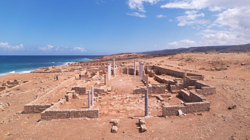
The cultural heritage sites along the coasts of Cyrenaica are of great historical and universal significance. These sites are facing a serious threat from coastal erosion caused by Climate Change. The impact of this erosion is already visible, with some of these sites at imminent risk of damage or loss. Among the most threatened is the ancient port of Apollonia of Cyrene [4]. About ninety kilometres from the city of Derna, the fulcrum of the violent climatic event, are the Cyrene ruins (now Shahat), included in the UNESCO World Heritage list since 1982 (in 2016 the site was classified among those in danger due to the occupation of ISIS). Local sources let the manifest that the sanctuaries dedicated to Apollo and Demeter suffered extensive flooding, while the roof of the museum was uncovered due to the fury of the hurricane. Significant damage was also recorded in Apollonia whose remains stand out near the city of Marsa Susa. Due to the interruption of road connections, archaeologists are currently unable to establish the extent of damage to monuments and museums [3].

Figure 1. Apollonia (Libya) was imaged by one of the Copernicus Sentinel-2 satellites on 12 April 2023 (Source Image: https://www.copernicus.eu/lv/node/12645).
Thanks to Copernicus (Figure 1), it is now possible to monitor the state of these valuable Cultural Heritage sites, take action to mitigate the effects of climate change and prevent further damage [4]. In September 2022, the Copernicus Support Office delivered the “Copernicus for the Preservation of Cultural Heritage” Webinar to help understand the benefits of Remote Sensing for cultural heritage monitoring, protection and management [5].

Figure 2. Libyan desert imaged by Copernicus Sentinel-2 satellites on 2 and 12 September (Source Image: https://www.copernicus.eu/en/media/image-day-gallery/storm-daniel-causes-flooding-libya).
.
Copernicus Sentinel Satellite data allow us to identify and map flood-affected areas in high definition, ensuring accurate monitoring and timely response during flooding events. For example, the two images, acquired by one of the Copernicus Sentinel-2 satellites on 2 and 12 September, show the Libyan desert before and after the aftermath of Storm Daniel (Figure 2). The image on the left depicts the desert in its normal state, while the image on the right shows the flooded areas in cyan and blue tones [6].
Additional maps and associated data are available on the Copernicus Emergency Management Service (EMS). In addition, the Copernicus CEMS Rapid Mapping module has been activated to assess the damages caused by the floods in eight Areas of Interest (AoI). This data visualization, based on CEMS data, depicts the damaged and destroyed buildings in the AoI of Derna, in which 3,925 buildings have been affected (Figure 3) [7].

Figure 3. Derna imaged by Copernicus Sentinel-2 satellites on 13 September (Source Image: https://www.copernicus.eu/en/media/image-day-gallery/severe-floods-devastate-derna-libya).
Remote Sensing enables the collection of valuable information helping to assess the condition of heritage sites, detect changes over time, and plan for their conservation and preservation. Remote Sensing is used in cultural heritage management in many ways: Documentation and Inventory, Condition Assessment, Change Detection, Environmental Monitoring, Archaeological Site Detection, Disaster Preparedness, Preservation Planning, Data Integration, Cultural Heritage Education, and International Collaboration. In summary, Remote Sensing technologies provide valuable tools for monitoring, protecting and managing Cultural Heritage sites. They enable data-driven decision-making, contribute to conservation efforts, and help ensure that these sites are preserved for future generations.
[3] https://news.italy24.press/trends/863211.html
[4] https://www.copernicus.eu/lv/node/12645
[5] https://www.youtube.com/watch?v=3YMnqDY4khg
[6] https://www.copernicus.eu/en/media/image-day-gallery/storm-daniel-causes-flooding-libya
[7] https://www.copernicus.eu/en/media/image-day-gallery/severe-floods-devastate-derna-libya